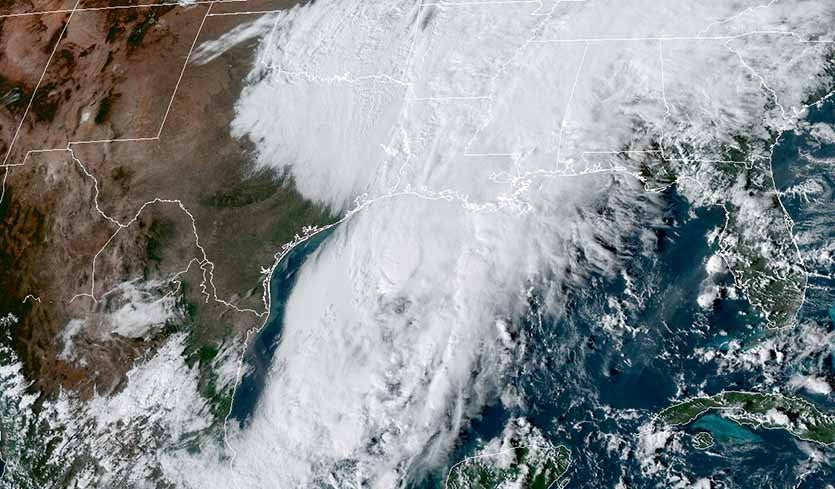
| Above: GOES-16 visible image of Tropical Storm Olga at 5:10 pm EDT October 25, 2019. Image credit: NOAA/RAMMB. |
In an exceptionally rare occurrence for late October, two new tropical storms formed simultaneously on Friday afternoon in the Atlantic—Olga in the Gulf of Mexico and Pablo in the northeast Atlantic near the Azores Islands. The formation of Olga and Pablo brings this year’s tally of Atlantic tropical cyclone activity to 16 named storms, 5 hurricanes, 3 intense hurricanes, and an ACE index of 120. The 1981 – 2010 averages for these quantities by October 25 were 10.8 named storms, 5.6 hurricane, 2.5 intense hurricanes, and an ACE index of 95.5, according to Dr. Phil Klotzbach, so 2019 is well above average in most metrics.
#Olga and #Pablo are the latest calendar year Atlantic named storms on record to be named simultaneously. The previous record was October 9 (set in 1878). #hurricane pic.twitter.com/smjZOU7ZYI
— Philip Klotzbach (@philklotzbach) October 25, 2019
Olga forms in the Gulf of Mexico
Satellite wind measurements and data from a Friday afternoon hurricane hunter flight found 40 mph surface winds in Tropical Depression 17 in the Gulf of Mexico, prompting NHC to upgrade it to Tropical Storm Olga. The most recent named storm to form this late in the calendar year in the Gulf of Mexico is Juan, which became a tropical storm on October 26, 1985.
Olga will be very short-lived, however. The Hurricane Hunters found that Olga was about to be overtaken by a cold front with even stronger winds near 45 mph behind it. Olga is expected to make landfall in Louisiana late Friday night after merging with the cold front and becoming a very rainy non-tropical low pressure system. Heavy rains from Olga will penetrate into southern Lower Michigan and southern Ontario by Saturday night. Update (11 pm EDT Friday): Olga was declared a post-tropical cyclone by NHC just six hours after it was named, with the cold front having absorbed it. The presence of the front boosted Olga's top winds to 50 mph, though, and the rainfall forecast remains on track.
 |
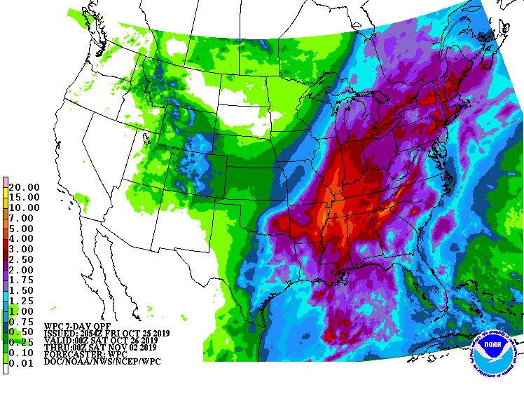
| Figure 1. Predicted 7-day precipitation amounts ending at 8 pm EDT Friday, November 1, 2019. Heavy rains from Olga will penetrate into southern Lower Michigan by Saturday night, treating Dr. Masters to a rare late-October tropical weather experience. This map also incorporates moisture predicted for later next week from a subsequent storm system. Image credit: NOAA. |
Heavy rains were already affecting a large area of Louisiana and surrounding states on Friday evening, as seen on New Orleans radar. Radar-estimated rainfall amounts in excess of two inches had occurred over a sizable swath of central Louisiana and southern Mississippi, as well as coastal Alabama. A Flash Flood Watch and Flood Advisory were in effect for the New Orleans metro area, where 2 – 4” of rain had fallen by 3 pm CDT Friday; another 1 – 3” was expected. NOAA’s Storm Prediction Center (SPC) has placed coastal southeast Louisiana and Mississippi in their “Slight Risk” area for severe weather on Friday, and a tornado watch was posted for portions of coastal southeast Louisiana, Mississippi, and Alabama. A number of tornado warnings have been issued in this region on Friday afternoon, but as of 5 pm CDT, no preliminary tornado reports had been posted by SPC.
Friday evening satellite images of Olga showed a messy-looking system with a modest-sized area of heavy thunderstorms along the northeast side of its circulation. Conditions were marginal for further development, due to high wind shear near 30 knots. However, Olga had favorable ocean temperatures near 29°C (84°F), and a very moist atmosphere with a mid-level relative humidity near 70%. The sea surface temperatures were about 1.5 – 2.0°C (2.5 - 3.6°F) above average for this time of year.
 |
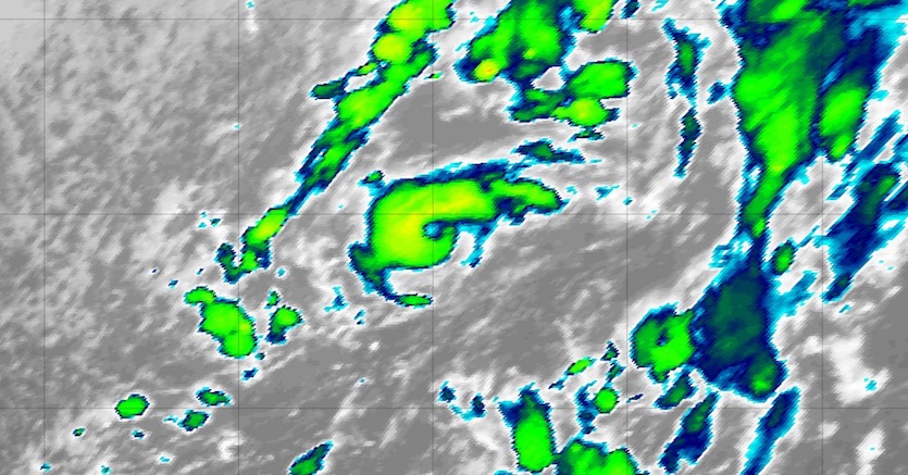
| Figure 2. Infrared image of Tropical Storm Pablo at 2045Z (4:45 pm EDT) Friday, October 25, 2019. Image credit: tropicaltidbits.com. |
Pablo forms near the Azores Islands
Not to be outdone by Olga, a compact cyclone west of the Azores was designated Tropical Storm Pablo at 5 pm EDT Friday. Pablo consisted of a tiny whirl with a focused core of showers and thunderstorms (convection) and an eye-like feature, all embedded within a much larger circulation linked to an upper-level low. Top sustained winds were 45 mph, and tropical storm-force winds extended out no more than 35 miles from the center.
The wind shear around Pablo was strong (30-35 knots), and sea surface temperatures were near 22°C (72°F), well below the 26°C (79°F) threshold typically associated with tropical development. However, the upper-level air was cold enough to make the air mass unstable and to support convection. Typically a cold-core upper low like this might evolve into a subtropical storm, but Pablo is so tiny that it has managed to carve out tropical characteristics within the much larger non-tropical upper low. “This is not unique and has occurred several times in the past, primarily during the latter part of the hurricane season,” said NHC hurricane specialist Lixion Avila in a forecast discussion.
Forecast models take Pablo east-southeast, then more rapidly northeast, on a track that could pass over parts of the Azores this weekend. The surrounding non-tropical low will bring winds and waves as strong or stronger than Pablo's, so local guidance on the impacts from Pablo will be handled as part of a broader envelope of warnings issued by the Portuguese Institute for the Sea and Atmosphere for the Azores. No major change in strength is expected before Pablo loses its identity in a couple of days.
Bob Henson co-wrote this post.


