WunderBlog Archive » Category 6™
Category 6 has moved! See the latest from Dr. Jeff Masters and Bob Henson here.So Long, La Niña; Arctic Temperatures Soar 63°F in 24 Hours
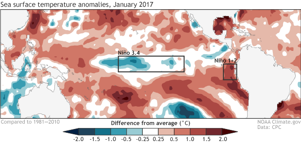
In its latest monthly advisory, issued Thursday, NOAA’s Climate Prediction Center (CPC) sounded the death knell for the 2016-17 La Niña. SSTs in the benchmark Niño 3.4 region (in the equatorial Pacific) warmed to 0.3°C below average during early February; SSTs of 0.5°C or more below average in this region are required to be classified as weak La Niña conditions. As further evidence of the demise of La Niña, subsurface cold waters across the equatorial Pacific have completely vanished, and much warmer-than-average waters built off the coast of Peru in late January and early February, bringing unusual El Niño-like flooding rains to that nation. The 2016 - 2017 La Niña event was one of the weakest and shorted-lived La Niñas on record, lasting just six months and peaking with sea surface temperatures (SSTs) in the Niño3.4 region of 0.8° below average. According to CPC, only one other La Niña since 1950 has been this short and weak: the 1967 - 1968 event, which lasted five months, and also peaked at SSTs of 0.8°C below average in the Niño 3.4 region.

Figure 1. Average sea surface temperatures during January 2017, shown as departure from the long-term (1981-2010) average. Weak La Niña conditions were present in the Niño 3.4 region, but the waters were growing unusually warm along the coast of Peru in the Niño 1+2 region. Climate.gov figure from CPC data.
The forecast: Neutral this summer, then El Niño this fall?
In a Thursday ENSO Blog entry, NOAA/CPC’s Emily Becker reviews the El Niño forecast for the rest of 2017. Most computer models agree that neutral conditions will continue into the summer, and forecasters estimate an approximately 60% chance of neutral conditions lasting through the spring. After that, it gets complicated. We have a very difficult time predicting the future beyond the March–May period: the so-called spring predictability barrier. “In fact, a forecast made in June for the sea surface temperature in December (six months away) can be more successful than a forecast made in February for May (three months away)!” Becker relates. Some of the computer models are calling for a return of El Niño conditions by the second half of 2017. CPC’s current consensus forecast for the September—November 2017 period estimates a 12% chance of La Niña conditions, 40% chance of neutral conditions, and a 48% chance of El Niño. The latest Australian Bureau of Meteorology models are more aggressive about El Niño, showing development by this spring. If El Niño materializes in 2017, it would give us an unusual three-year series of El Niño/La Niña/El Niño: something that has only happened once since 1950—in 1963/1964/1965.

Figure 2. Weather data from Kap Morris Jesup, Greenland—the northernmost land weather observing station in the world—shows the remarkable surge of warm air that invaded the Arctic this week. The temperature trace (red line in top graph) soared 63°F (34.8°C) in 24 hours, from -29°F at 15 UTC February 7 to 33°F at 15 UTC February 8. The temperature peaked at 35°F (1.5°C) at 21 UTC February 8.
Summer in February in the Arctic: temperatures surge 63°F in 24 hours in Northern Greenland
The temperature at the northernmost land station in the world, Kap Morris Jesup, located on the northern coast of Greenland at 83.65°N latitude, soared to a remarkable 35°F (1.5°C) on Wednesday—beating the previous day’s high of -22°F by a shocking 57°, and marking a temperature more typical of June at this frigid location. The mercury skyrocketed an astonishing 63°F (34.8°C) in just 24 hours, from -29°F at 15 UTC February 7 to 33°F at 15 UTC February 8. As summarized by Jason Samenow of the Capital Weather Gang on February 6, the incredible warmth in the Arctic is due to a massive hurricane-force North Atlantic storm that bottomed out on Monday with a central pressure of 932 mb—a common reading in Category 4 hurricanes, and one of lowest pressures ever measured in a storm in this region. (He noted that the strongest North Atlantic winter storms on record—in December 1986 and January 1993—had pressures of 900 and 916 millibars, respectively.) The warm air flowing into the Arctic this week was reinforced by a second massive extratropical storm that pounded Iceland on Wednesday, which brought sustained winds of 61 mph, gusting to 91 mph, to the Reykjavik Airport. Warm air near the freezing point—about 50 to 60°F above average in temperature—likely came close to the North Pole on Thursday morning, according to the latest temperature anomaly maps from the University of Maine’s Climate Reanalyzer website. A drifting buoy located near the Pole, at about 87°N latitude, recorded temperatures above freezing once in November 2016 and once in December 2016, and hit 32°F on Friday. The warm air in the Arctic this week continues a trend of record to near-record heat seen in the Arctic throughout the winter of 2016 - 2017. The warm air has helped bring about the lowest arctic sea ice extent ever recorded during January, according to the National Snow and Ice Data Center. in a February 20 interview in the Washington Post, atmospheric physics expert Kent Moore of the University of Toronto noted that these types of anomalous warming events have been recorded since the 1950s, but only occurred once or twice a decade. Record arctic sea ice loss in recent years is allowing these events to occur more frequently. Moore said: “As that sea ice moves northward, there’s a huge reservoir of heat over the north Atlantic. As we lose the sea ice, it allows essentially this reservoir of warmth to move closer to the pole.”
Jeff Masters

Figure 1. Average sea surface temperatures during January 2017, shown as departure from the long-term (1981-2010) average. Weak La Niña conditions were present in the Niño 3.4 region, but the waters were growing unusually warm along the coast of Peru in the Niño 1+2 region. Climate.gov figure from CPC data.
The forecast: Neutral this summer, then El Niño this fall?
In a Thursday ENSO Blog entry, NOAA/CPC’s Emily Becker reviews the El Niño forecast for the rest of 2017. Most computer models agree that neutral conditions will continue into the summer, and forecasters estimate an approximately 60% chance of neutral conditions lasting through the spring. After that, it gets complicated. We have a very difficult time predicting the future beyond the March–May period: the so-called spring predictability barrier. “In fact, a forecast made in June for the sea surface temperature in December (six months away) can be more successful than a forecast made in February for May (three months away)!” Becker relates. Some of the computer models are calling for a return of El Niño conditions by the second half of 2017. CPC’s current consensus forecast for the September—November 2017 period estimates a 12% chance of La Niña conditions, 40% chance of neutral conditions, and a 48% chance of El Niño. The latest Australian Bureau of Meteorology models are more aggressive about El Niño, showing development by this spring. If El Niño materializes in 2017, it would give us an unusual three-year series of El Niño/La Niña/El Niño: something that has only happened once since 1950—in 1963/1964/1965.
Figure 2. Weather data from Kap Morris Jesup, Greenland—the northernmost land weather observing station in the world—shows the remarkable surge of warm air that invaded the Arctic this week. The temperature trace (red line in top graph) soared 63°F (34.8°C) in 24 hours, from -29°F at 15 UTC February 7 to 33°F at 15 UTC February 8. The temperature peaked at 35°F (1.5°C) at 21 UTC February 8.
Summer in February in the Arctic: temperatures surge 63°F in 24 hours in Northern Greenland
The temperature at the northernmost land station in the world, Kap Morris Jesup, located on the northern coast of Greenland at 83.65°N latitude, soared to a remarkable 35°F (1.5°C) on Wednesday—beating the previous day’s high of -22°F by a shocking 57°, and marking a temperature more typical of June at this frigid location. The mercury skyrocketed an astonishing 63°F (34.8°C) in just 24 hours, from -29°F at 15 UTC February 7 to 33°F at 15 UTC February 8. As summarized by Jason Samenow of the Capital Weather Gang on February 6, the incredible warmth in the Arctic is due to a massive hurricane-force North Atlantic storm that bottomed out on Monday with a central pressure of 932 mb—a common reading in Category 4 hurricanes, and one of lowest pressures ever measured in a storm in this region. (He noted that the strongest North Atlantic winter storms on record—in December 1986 and January 1993—had pressures of 900 and 916 millibars, respectively.) The warm air flowing into the Arctic this week was reinforced by a second massive extratropical storm that pounded Iceland on Wednesday, which brought sustained winds of 61 mph, gusting to 91 mph, to the Reykjavik Airport. Warm air near the freezing point—about 50 to 60°F above average in temperature—likely came close to the North Pole on Thursday morning, according to the latest temperature anomaly maps from the University of Maine’s Climate Reanalyzer website. A drifting buoy located near the Pole, at about 87°N latitude, recorded temperatures above freezing once in November 2016 and once in December 2016, and hit 32°F on Friday. The warm air in the Arctic this week continues a trend of record to near-record heat seen in the Arctic throughout the winter of 2016 - 2017. The warm air has helped bring about the lowest arctic sea ice extent ever recorded during January, according to the National Snow and Ice Data Center. in a February 20 interview in the Washington Post, atmospheric physics expert Kent Moore of the University of Toronto noted that these types of anomalous warming events have been recorded since the 1950s, but only occurred once or twice a decade. Record arctic sea ice loss in recent years is allowing these events to occur more frequently. Moore said: “As that sea ice moves northward, there’s a huge reservoir of heat over the north Atlantic. As we lose the sea ice, it allows essentially this reservoir of warmth to move closer to the pole.”
Jeff Masters
The views of the author are his/her own and do not necessarily represent the position of The Weather Company or its parent, IBM.